"Narrative of the Cruise"
from
"The Gravity Measuring Cruise of the U.S. Submarine S-48"
(Return to Index)
by
by T. Townsend Brown
In preparation for the gravity cruise of the U.S.S. S-48, a new base station was established and the Meinesz apparatus calibrated at
the Naval Research Laboratory, Bellevue, Anacostia, D.C. The base station was located on the first floor of the annex, at an
approximate elevation of 23 feet above mean sea level.
1
The gravity was determined to one part in a million, representing the average of several long runs under carefully controlled
conditions. This station was also used to recheck the temperature constants of the pendulums. As the Meinesz apparatus had been
shipped from Holland, together with a new set of pendulums, it was necessary not only to assemble and calibrate the machine, but
also to ascertain that no damage had occurred to the delicate working parts during transportation This work was done in a small,
well-insulated room, the temperature controlled by a thermostat on the heater circuit with the result that there was less than 10
variation throughout the day and night. Observations were made at 37
O and 22
O C, this range representing the limit of the thermostat.
The variation in the period of the pendulums, due to expansion and contraction, was worked into temperature factors or constants,
one for each pair of pendulums; these were used in subsequent computations for the corrections of the observed period. Similar
corrections were determined for atmospheric density by close readings of the standard barometer and hygrometer. The error in the
recorded tilt of the swinging plane of the pendulums was likewise determined; this was done by placing the apparatus on the concrete
floor, accurately leveling the agate planes by means of the adjustable screw legs and making a short record; the trace of the true
zero would then appear on the developed film and the correction could be measured directly.
At the base station in the Naval Research Laboratory the time intervals of 1 second, used in determining the period of the pendulums,
were supplied as electric impulses from the crystal controlled high-frequency clock of the laboratory. The rate was so remarkably
constant, as to make it superior to any escapement chronometer. The impulses actuated the magnetic shutter of the recording
apparatus. Unfortunately, no minute designations, such as the omission of the sixtieth or zero second, were automatically sent out by
the clock; these had to he inserted manually by a key in the clock circuit. The method was difficult and tiring, subject to a certain
risk of error and was finally employed only at the beginning and ending of the record to identify the minutes. The observations at
the base station covered a period of about two weeks.
Upon completion of the cruise the gravity apparatus was again set up in Washington. It would have been desirable to have returned to
the established base station at the Naval Research Laboratory and to have checked against the original results; this would have
revealed directly ay change in the instrument, such as that resulting from warping of the pendulums or damage to the agate planes or
knife edges. Such return, however, Was considered inadvisable because of lack of time and available space. The equipment, therefore,
was set up in the newly constructed constant temperature and vibration insulated vault of the United States Coast and Geodetic Survey
in the Department of Commerce Building. Nothing was lost by reason of the change local gravity surveys conducted by the Department
connect the base station at the Naval Research Laboratory with that in the Commerce Building, so that it was not essential to return
to the original station. The recheck, though indirectly accomplished, was fairly satisfactory and revealed no serious instrumental
change. The new pendulums had not been quite stable during the trip, but the changes were small and they were obviously gradual, and
so the supposition, used for the deduction of the results, that the changes had occurred proportional to the elapsed time cannot have
been far from the truth. The control observations made at Guantanamo before and after the separate legs of the expedition are in good
harmony with these assumptions and so we may feel sure that this question has not introduced any appreciable uncertainty in the
results.
1 The excavation for the foundation for the extension of the annex, then under construction, was completed before any gravity
observations were made, so that it was not necessary to make any corrections for the removal of a significant mass close to the
instrument.
 TRANSPORTATION OF EQUIPMENT:
Alter the fine base station measurements were completed the gravity apparatus was carefully packed for transportation to the
submarine. The cases were handled with utmost care, every precaution being taken to guard them against possible shock which might
affect the adjustments; in every instance the handling was supervised by a member of the scientific party. From Washington to Norfolk
the shipment was made by river steamer, a large Navy lighter met the steamer upon arrival and carried the scientific party and the
apparatus to the U.S.S. Tarbell, visiting the navy yard. Here the apparatus was carefully hoisted aboard the Tarbell and secured in
a protected place for the long voyage. The destroyer, under the command of Lt. Comdr. H. K Fenn, made excellent time in spite of
heavy seas and on the morning of the fourth day arrived at (Guantanamo Bay, Cuba).
The submarine, then leaving the Canal Zone, would, arrive at Guantanamo as scheduled February 4, The gravity apparatus was unloaded
from the destroyer and stored at the office of the commandant and during the succeeding three days Dr. Meinesz, Messrs. Hess and
Brown engaged in computing the records made at the hose station in Washington.
THE SANTIAGO EARTHQUAKE:
An earthquake of considerable violence struck Santiago on February 3, 1932 at 1:17 am. The main shock lasted approximately 54
seconds, A minor shock had been felt the preceding afternoon, and shocks continued with generally decreasing intensity after the
main quake. The scientific personnel of the expedition were in Santiago at the time of the earthquake but they had the good fortune
both to be able to observe its effects and escape injury to themselves. The chronometers left at the Guantanamo Naval Street, where
the shocks were less intense, were tested.
THE BLAKE PLATEAU:
North of the Bahama region there is a broad relatively fiat shelf sometimes called the "Blake Plateau." It is about 200 miles wide
and slopes gently seaward to a depth of 600 to 700 fathoms (fig. 10). There is some evidence that submarine valleys have also been
incised into it, but the region has not as yet been charted in sufficient detail to identify such features. This shelf probably
represents a reef-free (pre-reef) surface. Little Bahama Bank probably marks the northern limit of reef growth at the time reef
building in the Bahamas began. It seems very likely that this reef-free surface extends under the Bahama region forming the basement
on which the reef material rests. This offers independent evidence that the reef material may be several thousand feet thick (700
fathoms, 4,200 feet).
INFERENCES BEARING ON THE CORAL REEF PROBLEM:
In the Bahama region evidence of great submergence and great thickness of reef material go hand in hand, an interesting point in
support of the subsidence theory. The direct evidence of subsidence in regions of barrier reefs and atolls has thus far been largely
limited to the observance of embayed shore lines, indicative of a submerged coast. But, although this may establish the fact of
subsidence, it does not indicate the amount of subsidence as clearly as submerged river valleys.
Daly�s glacial control hypothesis does not seem to apply to the larger features of the Bahama reefs; for, first, Pliocene fossils
were found at a relatively shallow - depth in the reef material (within the upper 10 percent of the reef material if this material
be as thick as estimated), and, second, because the reef material appears to be far thicker than the hypothesis requires. Certain
details of the upper portion of the reefs, however, such as the sand dunes, ocean boles (sink holes) extending to a depth of 350
feet, possible abrasion platforms, etc., may well be related to a Pleistocene withdrawal of the sea.
GRAVITY ANOMALIE IN THE BAHAMAS:
All but 2 of the 33 gravity stations in the Bahama region are negative, and the two positive anomalies were obtained on the northern
margin of the area. There are 15 stations at sea and 18 on land. The stations at sea are conspicuously more negative than the ones on
land, averaging -29 and -18, respectively. The stations located in the longitudinal submarine valleys are much more strongly
negatively than adjacent stations on land (on the reef material). This relation is well shown in figure 15, a section across the
Tongue of the Ocean and Exuma Sound south of Andros. Another section could be drawn 50 miles north of this one showing very similar
relations.
In attempting to interpret the anomalies in the Bahamas it is necessary: (1) To account for the general field of negative anomalies
over the whole region, and (2) the fact that the anomalies are more strongly negative over the valleys than over the reef areas. For
several reasons it is believed that the anomalies must be due some deviation from normal density in the rocks of the upper part of
the crust in this area rather than (A) any lack of isostatic equilibrium, or (B) any computational errors resulting from an incorrect
compensation for the effects of surrounding topography.
Reasons indicating that the anomalies of the Bahama region are not primarily due to lack of isostatic equilibrium are as follows:
The Bahama region is one of unusual stability at present, and seems to have been so for a considerable length of time geologically.
Earthquake epicenters are common in the Caribbean region, but completely lacking in the Bahama region, indicating stability and
freedom from tectonic disturbances. Reef building has gone on for at least part and perhaps the whole, of Tertiary and Pliestocene
time; and yet nowhere are these reefs found upliftted more than a few feet above present sea level, nor is evidence of down-warping
or submergence by tilting found anywhere over the large area of the platform in more than negligible amounts.18 Except for a slow
vertical submergence, accompanied by reef building, the region seems to have had quite an uneventful history since the valleys were
formed. Faults have not been noted on the valley floors, nor is there any evidence of warping of the longitudinal profiles of the
valleys on a scale large enough to be apparent from the sounding data available. If any lack of isostatic equilibrium exists at all
in the region, it might be expected to give positive rather than negative anomalies, since the deposition of the reef material might
result in an incompletely compensated load on the crust.
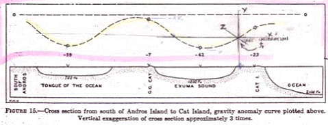 Figure 15 - Cross section from south of Andros Island to Cat Island, gravity anomaly curve plotted above.
Vertical exaggeration of cross section approximately 3 times.
Figure 15 - Cross section from south of Andros Island to Cat Island, gravity anomaly curve plotted above.
Vertical exaggeration of cross section approximately 3 times.
In the discussion of the strip of strong negative anomalies situated north of Puerto Rico and Haiti it was suggested that the broad
area of smaller anomalies in the Bahama region might represent the western termination of the strip. It was pointed out that the
negative strip was thought to be due to a down buckling of the lighter upper crust of the earth. Termination of the strip in a broad
field of smaller negative anomalies would probably have to be accounted for as either a broad gentle down warping of the crust by
internal compression or a thickening of the lighter upper crust by lateral compression. An anomaly field produced in either of these
manners would result in considerable tectonic disturbance of the Bahama region, but, as pointed out above, the Bahama region has been
stable and free from such disturbances since the valleys were submerged. The deformation forming the negative strip must have started
at some time during the Tertiary (the strip may still be in the process of formation); but the valleys are probably considerably
older than this. Thus the hypothesis that the negative anomalies of the Bahamas represent a dying out of the narrow strip of strong
negative anomalies is most unlikely.
18 Field, R.M. Geology of the Bahamas, Bull. Geol. Soc. Amer., vol. 42, p. 780, quotes Mr. Dixon as reporting raised strand line
reaching maximum of 8 feet above high-water mark. Field has also found wave-cut notches at 8 to 10 feet above sea level.
In the profile across the valleys (fig. 15) a correlation may he noted between topography and the anomaly curve above it. It might he
supposed that the negative anomalies (becoming increasingly negative over the valleys) are due to some undercompensation for the
effect of surrounding topography in the calculations of the anomalies: just as it was suggested that the positive anomalies over the
Bartlett Trough, which showed a correlation with topography were due to overcompensation. This, however, does not appear to be the
case in the Bahama region, because though the anomalies show a correlation to topography in cross profiles, such as figure 15,
profiles parallel to the length of the valleys show no such correlation at all. The anomalies over the valleys do not show any
relation whatsoever to changes in depth of the bottom. Thus it may he said the anomalies in the Bahamas are not due primarily to
either any lack of isostatic equilibrium or to errors inherent in the computations (such as the incorrect consideration of the
effects of surrounding topography, etc.) but rather to the remaining possibility namely, deviations from assumed density in the rock
beneath and around the stations.
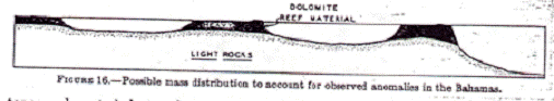 Figure 16 - Possible mass distribution to account for observed
anomalies in the Bahamas.
Figure 16 - Possible mass distribution to account for observed
anomalies in the Bahamas.
The simplest. mass distribution to account for the anomalies in the Bahamas is as follows: (1) The general field of negative
anomalies over the whole region is a result of a great thickness or light sedimentary rocks19 beneath the area. These rocks, as
previously suggested, may he folded, thus accounting for the relatively great thickness of light sedimentary rocks necessary an
anomaly as large as, for example, -62 in Exuma Sound. (2) The smaller negative anomalies of the reef areas, as compared to the
valley areas, may he due to the fact that the reef material, dolomite, is relatively dense and thus displaces the anomaly field in
a positive direction, though not to a sufficient extent to overcome the larger negative effect of the postulated great thickness of
tight rocks beneath the reef material. (See fig. 16).
Specific gravitics of the carbonate minerals
Calcite - 2.715
Aagonite - 2.94
Dolomite - 2.87
The mineral composition of the reef material from the boring on New Providence Island consisted largely of calcite to a depth of 165
+/- feet, and below that largely of dolomite. Near the surface the rock was very porous but the porosity decreased rapidly with depth
so that at 390 feet it was only about 5 percent. The specific gravity of the core at this depth, considering the
pore space to be filled by sea water, was 2.68. The composition was 86 percent dolomite and 14 percent calcite. The changes with
depth show clearly an increase in dolomite and a decrease in porosity, so that the density of the reef material might soon approach
2.87, the density of the mineral dolomite. Small amounts of aragonite or siderite might increase the density, and likewise the
presence of calcite decrease it. Thus the 4,000 feet of reef material might have a density excess of 0.2. This could account for
the fact that the anomalies on the reef material are less negative than those over the submarine valleys.
19 originally suggested by Bowie. See quotations by Field in Bull. Geol. Soc. Am., col. 42, p.763, 1931.
SUMMARY AND CONCLUSION:
Gravity anomalies south of Cuba in the Bartlett Trough region are strongly positive. In the whole Gulf and Caribbean region the
generalization seems to hold that the deeper the water the more strongly positive the anomalies.
A great scarp among the northern margin of the Bartlett Deep is thought to be a normal fault. After a consideration of the regional
structure, it was suggested that the Bartlett Trough is primarily the result of horizontal movement along a vertical shear which has
relieved this area from compression and thus allowed extensive down-faulting.
The strip of strong negative anomalies north of Puerto Rico and Haiti was further investigated. Apparently it terminates rather
abruptly at the east end of Cuba.
In the Bahamas strong evidence was found to show that a great submergence has taken place. Submarine valleys eroded apparently by the
action of running water under subaerial conditions, are now found 14,000 feet below sea level. The probable great thickness of reel
deposits measurable in thousands of feet, may also be a result of the magnitude of subsidence.
Of the 33 gravity anomalies in the Bahamas all but two are negatives. Those on the reef material are less negative than those over
the submarine valleys. It is concluded that the general field of negative anomalies is due to a great thickness of light sediments
beneath the Bahamas, but that the dolomite reef material is relatively heavy thus making the anomalies on the reef material less
negative than these over the submarine valleys.
ACKNOWLEDGMENTS:
I wish to express my appreciation to my colleague, Prof. R.M. Field, Director of the Expedition for his enthusiastic interest in the
various geological problems of the West Indies, and for his constructive criticism of my report.
I am deeply grateful to Dr. F. A. Vening Meinesz for the fundamental concepts regarding the nature and interpretation of gravity
anomalies. Many of the ideas appearing in this report are his. I wish, however, to take complete responsibility for the details of
the report inasmuch as Dr. Meinesz was unable to collaborate in the actual writing of it since be had to return to Holland to
complete his reports on the East Indies and make ready for another gravity-measuring cruise.
